
Where are we?
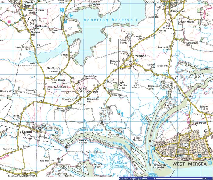
Winstred Hundred is a large, predominantly rural, area overlooking Mersea Island in the Blackwater Estuary, and is bounded to the north-west by Abberton Reservoir, to the south by the Salcott Channel with a land-boundary to the north-east shared with the parish of Abberton & Langenhoe.
There are lots of great places to walk in the parish, if you want to go further afield, though, a good website with lots of free to access walks, is https://www.walkinginengland.co.uk/essex.
About Winstred Hundred
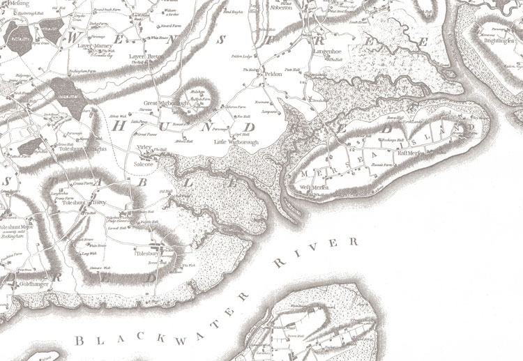
Winstred Hundred Parish takes in the local communities of Salcott cum Virley, the Wigboroughs (Great and Little) and Peldon. The name of the parish has a long and honourable tradition being founded on one of the original Hundreds of the County of Essex (Wenstree Hundred), although this modern incarnation covers a somewhat smaller area. Each of the villages comprising the Parish has its own background character.
Being just outside the oldest recorded town in the country it is inevitable that the thought of local history will come to some folks’ mind. This page gives an insight into the history of the villages comprising the parish and/or historic events affecting them.
Peldon

Peldon is the largest of the villages comprising modern Winstred Hundred and is situated just a few miles south of Colchester.
The village name is a corruption of the original Anglo-Saxon name of Piltondone with the ‘Done’ part of this being a description of the hill Peldon is built upon. Records documenting the existence of the village date as far back as 950AD and examination of these shows what used to be a thriving rural community with substantial farming and salt-production activities on what were extensive salt-marshes to the south/south-east.
These salt-marshes also fed another thriving local industry with the village (and the Peldon Rose pub in particular) being active in smuggling through use of the large numbers of brooks and inlets in the area. Throughout its’ history, though, the villages main claim to fame is probably for being the epicentre of the strongest earthquake to hit Britain which took place on the morning of 22nd April 1884.
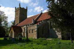
A recent Archaeological study in the graveyard at St Mary’s, was hoped to find some Saxon artefacts, sadly none were found although some Roman pottery shards were.
Great Wigborough
Just over a mile to the south-east of Peldon, the main part of Great Wigborough is uphill from its sister-village, Little Wigborough with wide views over farmland to Mersea Island.
The history of the village appears to be closely associated with Abbots Hall which was owned by the Barking Nunnery until the 16th century – the farm by the same name is now the HQ of the Essex Wild Life Trust and is also central to pioneering work in managed retreat of coastline.
Little Wigborough

Located just over a mile south of Peldon and between Great Wigborough and the Mersea and Salcott creeks, Little Wigborough is a small village overlooking the salt marshes and the estuary of the river Blackwater. Little Wigborough is mentioned in the Domesday Book under the name of Wigheberga, with the land belonging to Hamo Dapifer.
The Norman Church is adjacent to Copt Hall, an old Manor House, which is now rather more known for its access to the Copt Hall Marshes These marshes are a National Trust managed Site of Special Scientific Interest, where headland paths have been created on farmland to give access to the sea walls overlooking the salt marshes which every year are home to large flocks of overwintering wildfowl and wading birds.
Salcott-cum-Virley
The cum in Salcott-cum-Virley signifies the union of two church parishes into one, these being the original parishes of Salcott and Virley.
Virley

Lying just over a mile west of the Wigboroughs, Virley is a small village that appears to owe its name to its Norman owner at the time of the Domesday Book, Robert de Verli whose name, as an interesting point of trivia, appears in Edward Marston’s novel “The Ravens of Blackwater” which gives an interesting historical context of the area some 20 years after the conquest..
St Mary’s Church at Virley was one of the buildings most heavily damaged by the earthquake of 1884 with towers, parapets and roofs partially collapsing.
Salcott

Adjacent, and eastward, of Virley, Salcott is located at the head of a navigable creek through the salt marsh to the Blackwater estuary. The village was originally known as Salcott Wigborough, being an outlying hamlet of Great Wigborough, although there is also some evidence to suggest the name is derived from the salt marshes with some historical accounts referring to Saltcott.
